Chris Chapman. Oceanographer.
Climate Scientist.
Coffee Enthusiast.
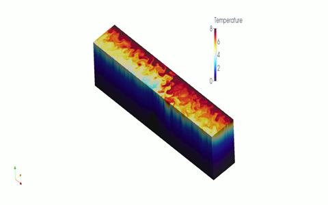

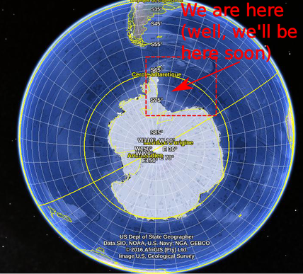 I'm just about ready to leave for a 6 weeks a sea, confirming my transition from a mathematician to a "real" oceanographer as part of the Water-mass transformation and Pathways In The Weddell Sea (WAPITI) project, an EU funded project run by my boss, oceanographer and noted acronym creater Jean-Baptiste Sallée. WAPITI will head to the Weddell sea, of the coast of west Antarctica, aboard the RSS James Clark Ross and I'll be attempting to keep this blog updated as we intrepid explorers brave the cold, the waves and man-eating penguins of the far south in the name of science. What is WAPITI and why, in this day and age of satellites, supercomputers and cheap postdocs would we get on a boat and bob around in the ocean for a few months? Firstly, why the Weddell? The Weddell Sea is the ocean that lies between the Antarctic Peninsula and the Antarctic Continent. The circulation in the region is a gyre, a circular flow that intensifies along the western coastline. 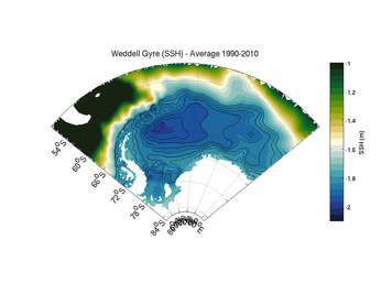 The sea-surface height in the Weddell Sea, as determined by the FESOM ocean model. Flow follows the contours in a clock-wise direction. The sea-surface height in the Weddell Sea, as determined by the FESOM ocean model. Flow follows the contours in a clock-wise direction. Gyres are generally thought to be driven by wind blowing over their surface. In fact, gyre flow is one of the most celebrated results in oceanography. But the Weddell is covered by sea-ice, that extends further north in winter and retreats in summer. Sea-ice modifies how the wind "talks" to the ocean in subtle ways that could impact the Weddell Sea gyre. 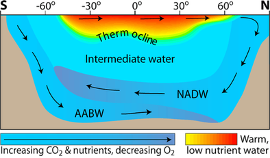 From: http://www.seos-project.eu From: http://www.seos-project.eu Oceanographers can also be a bit obsessed with the Weddell as it is one of the few regions on Earth where Antarctic Bottom Water (AABW). AABW is the densest (it's cold and salty), and hence the deepest, water found in the oceans: it fills the ocean from the bottom-up. AABW is formed near the ocean surface in a complicated process involving both freezing water to form ice and cooling from winds blowing over the ocean. Then, as it is so dense, it sinks. Because AABW is formed at the surface, when it sinks it takes with it dissolved oxygen and CO2. Once the CO2 is in the deep ocean, it stays there for hundreds, perhaps thousands of years. The diagram below gives you an idea of what's going on. That's all well and good. But AABW is notoriously difficult to monitor. Once it's formed, it plunges straight to the bottom of the ocean, deeper than most of our instruments are able to measure. We also can't see it from satellites. Even in the regions where the AABW is at the surface, the ocean is generally covered by ice, which make satellite observation impossible. 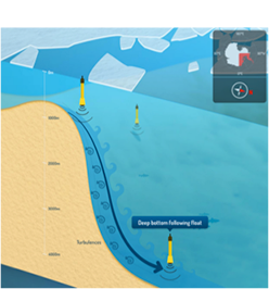 From the WAPITI website. Design by http://cyriljagot.com/ From the WAPITI website. Design by http://cyriljagot.com/ Additionally, no one really knows what's going on under that ice? How does sea ice affect the ocean circulation? We have some ideas, but they're mostly from the Arctic, where the ocean dynamics are quite different? We can, of course, blast this problem with a big ocean model run on a supercomputer, but models have struggled to get the flow right in the Weddell sea, and we really don't have enough data to validate a model anyway. So, we're going to get on a big boat, head south and measure the hell out of the region. What will we be doing? For one, we're going to deploy some special robotic floats. These floats drift (called RAFOS) with the current and measure the current speed as they go. Our floats are special as they are designed to follow the AABW as it flows through the Weddell Sea. These floats are even acoustically tracked, so they don't need to surface like Argo floats to talk to satellites, which means that sea-ice at the surface is no impediment! We're also going to be measuring the strength of the Weddell gyre, using current measurements from moorings and ship based instruments called an Acoustic Current Doppler Profiler (ADCP), as well as a battery of other oceanographic instruments. 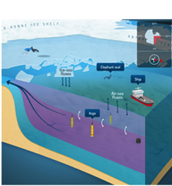 From the WAPITI website. Design by http://cyriljagot.com/ From the WAPITI website. Design by http://cyriljagot.com/ What we hope to achieve is to observe the formation of the AABW, how it gets mixed up by turbulence along the Antarctic coast, and how the Weddell gyre acts to move this water from its formation zones to the open ocean. Over the next few weeks I'll fill in the gaps in this overview, explain what we do on this cruise, and why we do it. I'll also try to put things in context: what does the Weddell Sea mean for the rest of the climate system, and how does our mission help to fill the gaps in our knowledge.
There will also be lots and lots of photos of pieces of ice and charismatic megafuna. So stay tuned. Les commentaires sont fermés.
|
Chris Chapman
I'm a physical oceanographer at LOCEAN Paris. My research concentrates on the Southern Ocean and its role in the climate system. ArchivesCategories |
 Flux RSS