Chris Chapman. Oceanographer.
Climate Scientist.
Coffee Enthusiast.


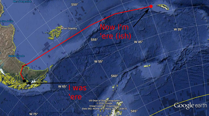 The most accurate chart in the world! 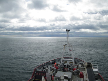 The James Clark Ross leaves Punta Arenas - heading for parts unknown.... to those who have never heard of Antarctica. The James Clark Ross leaves Punta Arenas - heading for parts unknown.... to those who have never heard of Antarctica. I'm aboard the RSS James Clark Ross, having left Punta Arenas in the far south of Chile. We're "steaming", to use the nautical term, for Bird Island in the South Georgia island chain. We will be dropping off some lucky scientists who will be spending some time there taking lake sediment samples, before making a turn to the south. It's after this turn where my work really begins. I'm charged with measuring the temperature and salinity "profiles" (that is, measuring the temperature and salinity as they change with depth) along a "transect" (A23 to be precise - I'll explain what that means in my next post). Why do oceanographers bother measuring T & S? And how, in a deep, constantly moving ocean, do we do it? Today, I'll briefly explain the former question. A little later, I'll describe the later. Why are T & S important? Well, for a start, animals that live in the ocean are generally adapted to certain temperatures and salinities. Coral is a great example, and one that gets a lot of press. Tropical corals can only survive in a narrow temperature range: when the waters get too warm (as is already occurring in some parts of the world as global warming starts to leave its mark on the planet), the corals get stressed and, eventually, die. Almost every animal in the ocean exploits some ecological niche, and both T & S play a key role in defining them. However, for a physical oceanographer such as myself, temperature and salinity are so much more than just two ingredients essential for marine life on Earth. They are also primary drivers of the ocean circulation - a fundamental component of the climate system. Both temperature and salinity influence ocean circulation through their influence on the density (that is the mass of the water in a particular volume, say one liter - sometimes called the buoyancy) of ocean water. Warmer water, all things being equal, is less dense (we could also say "lighter" or "more buoyant") while colder water is more dense ("heavier" or "less buoyant"). Salt has a similar effect: after all, if you 10g/oz/whatever quantity to a bottle of water, it will weigh 10g/oz/whatever more than before and hence be more dense (as the volume of liquid hasn't really changed). If you drop denser water in lighter water, it will sink (yes, yes, you the oceanographer in the crowd, I know it will entrain fluid and mix as it does. Shut up for a second and let me go on) until it reaches a level where its density is the same as the density of the surrounding fluid. This effect is why the densest ocean waters - the coldest and the saltiest - are the deepest: they've had time to sink the bottom and "fill" the ocean from the bottom up. The change in the density of seawater with its depth is what oceanographers call "stratification" and it's a fundamental property of the ocean that affects all sorts of things, such as ocean turbulence and how similar the currents at the surface are to the currents at depth. 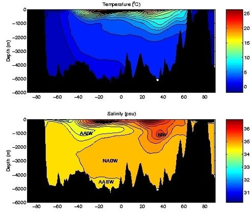 A slice of temperature (top) and salinity (bottom) through the Atlantic Ocean. Some of the water masses are labelled in the salinity image. Image from: http://www.soes.soton.ac.uk/teaching/courses/oa631/hydro.html 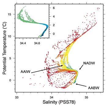 It should be obvious to the most dimwitted individual where to find the AABW! From colleagues at the Muséum National d'Histoire Naturelle, Paris: http://edu.mnhn.fr/mod/book/view.php?id=5405&chapterid=96&lang=en It should be obvious to the most dimwitted individual where to find the AABW! From colleagues at the Muséum National d'Histoire Naturelle, Paris: http://edu.mnhn.fr/mod/book/view.php?id=5405&chapterid=96&lang=en The temperature and salinity of the oceans change depending on where you are, and in what season. Obviously, water is colder - hence denser - at the poles than in the tropics, simply because the tropic get more and stronger sun than the Arctic or Antarctic. However, some regions of the tropics get a lot of rain, which dilutes the salt in the water, while some sub-tropical regions have very little cloud cover, so the sun beams in a bakes the ocean surface. In these "horse latitudes" the salinity is very high as much of the surface water evaporates, leaving more concentrated salt. Hence water in the sub-tropics can often be quite dense, even though the water can be quite warm.
By collecting thousands upon thousands (upon thousands) of water samples we can start to see patterns between the temperature and salinity of the water, and where it has come from. For example, as I was describing before, warm, salty water was probably formed in the sub-tropical regions, while warm, yet non-salty water (so called "fresh water", even though it still may have plenty of salt in it) might have come from the wet-tropics. We call these unique(ish) combinations of temperature and salinity "water masses", and any attendee of an oceanographic conference will hear a barrage of odd names and acronyms - NADW, AAIW, Mode Water, etc... that are the names for different water masses. Each water mass comes with baggage: a story about how it managed to find itself with the T & S it possesses. And finding a particular water mass a long way from home can help give us an idea of the pathway that it took to get from its point of formation to wherever it has ended up, which can in turn help us understand how the ocean currents move. On the WAPITI cruise we'll be chasing so-called "Antarctic Bottom Water" (abbreviated AABW). This water mass is the densest you can find: it's cold because it comes from the coasts of Antarctica, one of the coldest regions on the planet. It's salty, because near Antarctica lots of sea-ice is formed. The water that makes up sea-ice is quite fresh - sea-ice rejects salt from the water as it forms - and this salt ends up in the water below the sea-ice. Thus, AABW has a pretty clear signature: colder than -0.2 degrees C (it won't freeze because it's both too salty and under pressure) and saltier than about 34.6 psu (that's Practical Salinity Units for those not up on their oceanographic metrology). AABW is so dense that it sinks pretty-much straight to the bottom upon being formed. But it doesn't just lay around on the ocean floor like Brad Pitt in the underrated Tarantino film True Romance (you have no idea what I'm talking about, do you?). We find AABW all through the Atlantic Ocean, indicating that it has spread to the north after being formed. What's more, AABW is rich in dissolved CO2 that it has absorbed from the atmosphere. Since AABW stays on the ocean floor for centuries or even millennia, its CO2 stays there with it, where it can't contribute to global warming. But wait, there's more! Through the magic of a simplified description of ocean currents, called the geostrophic balance approximation (which says that the Corriolis force and the pressure gradient force are the dominant forces in the ocean, and that the two act to balance each other), we can directly relate the ocean's density structure to the ocean currents themselves. So if we know the ocean's density structure (that is, how the density changes in latitude, longitude and depth) we get an approximation of the ocean current speed for free (although we miss a very, very important constant factor called the "barotropic current" that can be thought of as the average of the current speed in the water column). On the WAPITI cruise, we'll use our "transects" or "sections" of T & S to estimate the geostrophic current speeds in the Weddell Sea, which can give us an idea about how rapidly the AABW is moved from its formation regions to the open ocean. This (longish) post explains a little about why T & S are important to measure. It's a simplified picture, and I've skipped a bunch of details like the effect of mixing, internal waves and the importance and difficulty of estimating the barotropic current. But it should give you the gist. In my next post, I'll show you how we measure temperature and salinity from ships, with some real world examples from our first CTD casts.
0 Commentaires
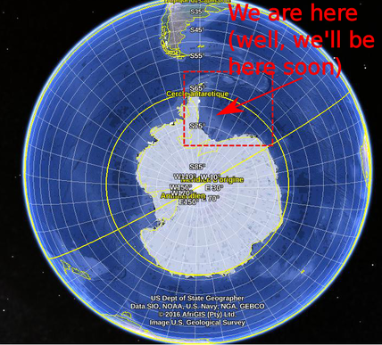 I'm just about ready to leave for a 6 weeks a sea, confirming my transition from a mathematician to a "real" oceanographer as part of the Water-mass transformation and Pathways In The Weddell Sea (WAPITI) project, an EU funded project run by my boss, oceanographer and noted acronym creater Jean-Baptiste Sallée. WAPITI will head to the Weddell sea, of the coast of west Antarctica, aboard the RSS James Clark Ross and I'll be attempting to keep this blog updated as we intrepid explorers brave the cold, the waves and man-eating penguins of the far south in the name of science. What is WAPITI and why, in this day and age of satellites, supercomputers and cheap postdocs would we get on a boat and bob around in the ocean for a few months? Firstly, why the Weddell? The Weddell Sea is the ocean that lies between the Antarctic Peninsula and the Antarctic Continent. The circulation in the region is a gyre, a circular flow that intensifies along the western coastline. 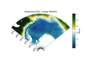 The sea-surface height in the Weddell Sea, as determined by the FESOM ocean model. Flow follows the contours in a clock-wise direction. The sea-surface height in the Weddell Sea, as determined by the FESOM ocean model. Flow follows the contours in a clock-wise direction. Gyres are generally thought to be driven by wind blowing over their surface. In fact, gyre flow is one of the most celebrated results in oceanography. But the Weddell is covered by sea-ice, that extends further north in winter and retreats in summer. Sea-ice modifies how the wind "talks" to the ocean in subtle ways that could impact the Weddell Sea gyre. 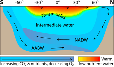 From: http://www.seos-project.eu From: http://www.seos-project.eu Oceanographers can also be a bit obsessed with the Weddell as it is one of the few regions on Earth where Antarctic Bottom Water (AABW). AABW is the densest (it's cold and salty), and hence the deepest, water found in the oceans: it fills the ocean from the bottom-up. AABW is formed near the ocean surface in a complicated process involving both freezing water to form ice and cooling from winds blowing over the ocean. Then, as it is so dense, it sinks. Because AABW is formed at the surface, when it sinks it takes with it dissolved oxygen and CO2. Once the CO2 is in the deep ocean, it stays there for hundreds, perhaps thousands of years. The diagram below gives you an idea of what's going on. That's all well and good. But AABW is notoriously difficult to monitor. Once it's formed, it plunges straight to the bottom of the ocean, deeper than most of our instruments are able to measure. We also can't see it from satellites. Even in the regions where the AABW is at the surface, the ocean is generally covered by ice, which make satellite observation impossible. 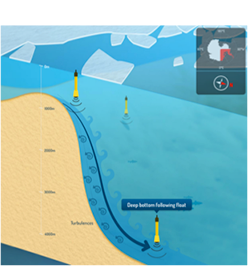 From the WAPITI website. Design by http://cyriljagot.com/ From the WAPITI website. Design by http://cyriljagot.com/ Additionally, no one really knows what's going on under that ice? How does sea ice affect the ocean circulation? We have some ideas, but they're mostly from the Arctic, where the ocean dynamics are quite different? We can, of course, blast this problem with a big ocean model run on a supercomputer, but models have struggled to get the flow right in the Weddell sea, and we really don't have enough data to validate a model anyway. So, we're going to get on a big boat, head south and measure the hell out of the region. What will we be doing? For one, we're going to deploy some special robotic floats. These floats drift (called RAFOS) with the current and measure the current speed as they go. Our floats are special as they are designed to follow the AABW as it flows through the Weddell Sea. These floats are even acoustically tracked, so they don't need to surface like Argo floats to talk to satellites, which means that sea-ice at the surface is no impediment! We're also going to be measuring the strength of the Weddell gyre, using current measurements from moorings and ship based instruments called an Acoustic Current Doppler Profiler (ADCP), as well as a battery of other oceanographic instruments. 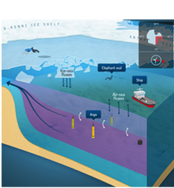 From the WAPITI website. Design by http://cyriljagot.com/ From the WAPITI website. Design by http://cyriljagot.com/ What we hope to achieve is to observe the formation of the AABW, how it gets mixed up by turbulence along the Antarctic coast, and how the Weddell gyre acts to move this water from its formation zones to the open ocean. Over the next few weeks I'll fill in the gaps in this overview, explain what we do on this cruise, and why we do it. I'll also try to put things in context: what does the Weddell Sea mean for the rest of the climate system, and how does our mission help to fill the gaps in our knowledge.
There will also be lots and lots of photos of pieces of ice and charismatic megafuna. So stay tuned. |
Chris Chapman
I'm a physical oceanographer at LOCEAN Paris. My research concentrates on the Southern Ocean and its role in the climate system. ArchivesCategories |
 Flux RSS