Chris Chapman. Oceanographer.
Climate Scientist.
Coffee Enthusiast.

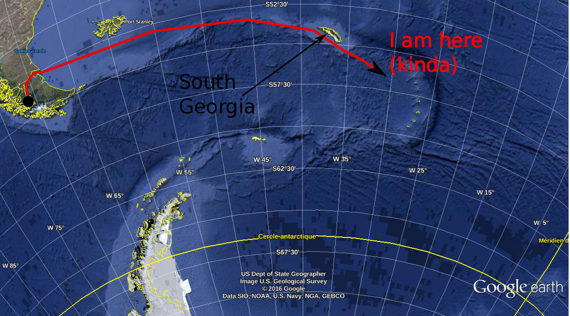 We're a long way from Kansas, Toto. Not sure why that's important, since neither of us are from Kansas, but it's true nevertheless. In my last post, I explained a little about why we oceanographers are interested in the temperature (T) and salinity (S) of the oceans. Today, I'll show you how we do it from ocean going research ships, illustrating with a couple of photos from the first couple of measurements we made south of the island of South Georgia (one of the many places that Ernest Shackleton didn't die). How it's done. This is a CTD. 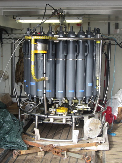 CTD is a complicated way of saying bottle rack. CTD stands for Conductivity, Temperature, Depth. It's not just a clever name: this device really does measure the conductivity, the temperature and the depth. Oceanographers are known for their creative naming conventions. Conductivity is a measure of how electrically conductive a substance is (if you've ever done electronics, you'll know conductivity as the inverse resistance). Water that is more saline is more electrically conductive. With careful calibration of the instrument - a job in an of itself - if we know the conductivity of a water sample, we know its salinity. From afar, the CTD might look like a rack of bottles. That's because a CTD is, primarily, a rack of bottles. Ours has 24 bottles that can hold 12 litres of water. These bottles are attached by latex wires to a magnetically operated trigger. By lowering the CTD into the ocean on a winch, we can take water samples at any depth that interests us. An operator, usually a skilled and experienced oceanographer, but in some cases, me, "fires" a bottle, which causes it to snap closed at a depth that interests us. We've got 24 bottles, which means we could, if we wanted to, sample water from 24 different depths. However, for a lot of chemistry and biology work (measuring, for example, the amount of CO2 or oxygen dissolved in the water, or the amount of plankton or whatever), you need a lot of water, so we'll often "fire" two bottles at the same depth to give our colleagues more material to work with. Here's a CTD on wire being winched over the side of the ship. 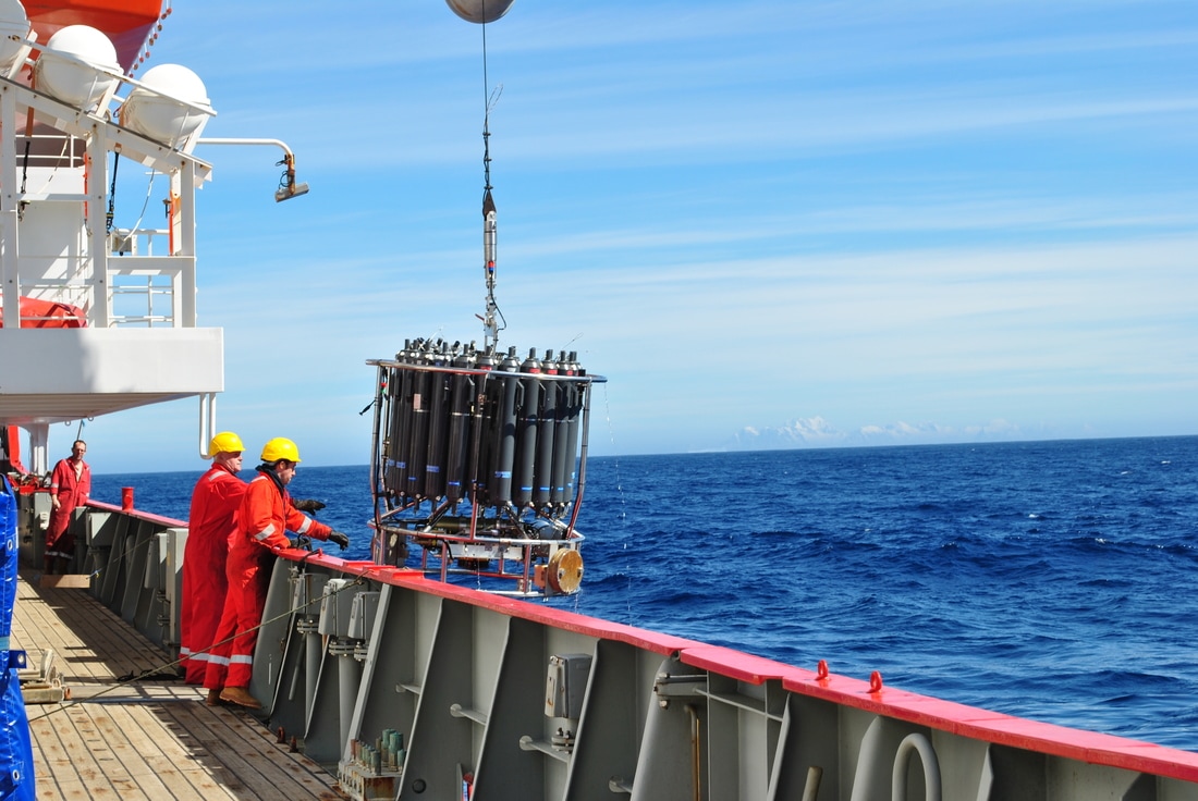 This guy has a date with the bottom of the ocean! (you can just make out the mountains of South Georgia in the background) 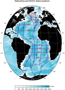 WOCE sections in the Atlantic (from the WOCE Atlas woceatlas.ucsd.edu/) WOCE sections in the Atlantic (from the WOCE Atlas woceatlas.ucsd.edu/) We lower the CTD down to about 10 meters above the ocean floor (getting the CTD stuck on the bottom of the ocean is generally considered to be a dick move). We then winch it up to the surface, taking water samples as we go. When we get it back on the ship, the water samples are divided up among the assembled waiting chemists, who then proceed to science the crap out of them. Some of the water samples are scienced in labs on board the ship. Others are packed up and sent back home at the end of the campaign for further sciencing on land. Some lab equipment, such as electron microscopes, and... I dunno... an elephant or something (I'm not a chemist) you just can't take on a boat. These days, CTDs also have electronic temperature and conductivity (salinity) probes which measure, in real time, the T and S of the ocean, as well as some other interesting quantities such as "florescence" (how much ocean water glows when you shine a light on it... an indirect measure of the amount of phytoplankton in the water) or dissolved oxygen. The information is the sent back up to the ship via a cable and we can monitor how the T & S change with depth as the CTD is lowered and raised. This real time information helps us decided at exactly which depth we want to sample water at. Most plankton activity, for example, happens relatively close to the surface in an area called the "mixed layer" whose depth depends on the strength of the wind, waves, location, time of year, etc... The mixed layer gives itself away by being ... well... mixed - that is, its temperature and salinity are relatively constant throughout its depth. The bottom of the mixed layer is marked by a very strong temperature gradient. For our friends the biologists, we want to be very sure to sample this region, so we keep a close eye on the temperature as the CTD goes down (and comes up again) to give us an idea about where in the water column to sample. The electronic temperature and conductivity probes are good enough these days that we use their data pretty much as we would bottle samples. However, we do check the temperature and salinity collected via the bottle samples against the electronic equipment to make such that both are working well, and that the calibrations haven't "drifted" too much. Where do we do it? The oceans are big. Boats are small. Even with 10,000 boats piloted by crack team of super intelligent talking mice, covering the world's oceans would be a futile task. That's why, back in the late 80's, a scheme was launched, called the World Ocean Circulation Experiment (WOCE) to divide the ocean's up into "sections" or "transects". These sections were carefully chosen because the people in charge of WOCE wanted to measure certain interesting ocean phenomena. For example, the section SR1, which runs between the tip of South America and the Antarctic Peninsula was designed to measure the strength of the Antarctic Circumpolar Current as it passes through Drake Passage (the passage between, err... the tip of South America and the Antarctic Peninsula). Each section is divided into a number of "stations": points along the line where we deploy our CTD (and other instruments if you've got 'em). The ship comes to a stop at each of the stations, and we role out the ol' CTD and take a profile at that location. Ocean going field campaigns should, subject to weather conditions, timing, cruise objectives, etc... take their measurements along one of these "sections" at its appropriate stations. By repeatedly sampling the same parts of the ocean, we can build up a good body of knowledge about the ocean in particular areas, as well as see how things change in that area with time. Systematic sampling is usually (although not always) better than sampling au hazard. It enables easy comparison with what's gone on before and allows (kinda) continuous monitoring of certain interesting phenomena. Before we get to the Weddell Sea, we on the WAPITI cruise will be "occupying" (that is, re-sampling) the southern part of the A23 line - between the bottom of South Georgia island and the Antarctic continent. A23 is a bit of a "forgotten" transect, having only been occupied a few times previously. As it's on the way to our principle destination, we (and by "we" I mean my boss and the head-honchos at the British Antarctic Survey) thought that it would be a good idea to take some samples along this transect during the voyage. 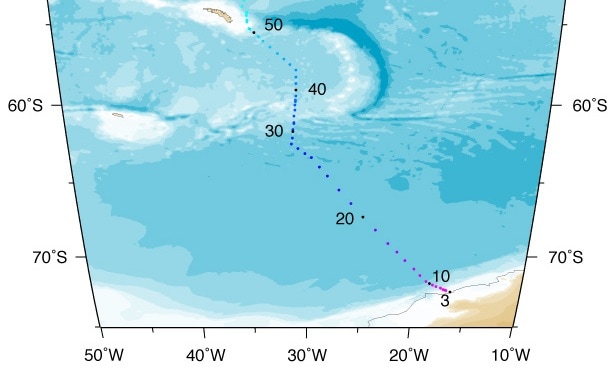 We're doing this bit (also from the WOCE Atlas: woceatlas.ucsd.edu) So that's the basics of how we measure T & S (and some other stuff) during a research cruise. I should mention that this isn't the only way to measure T & S. We can also measure both quantities by satellites (but only at the surface, of course) by moored instruments stuck to the ocean floor (but on in one place, of course) or by drifting robots called Argo floats (but then you don't know where exactly you'll measure).
In my next post I'll describe the hows and whys of measuring the speed of ocean currents and why that's an important thing to do.
4 Commentaires
4/21/2020 08:00:30 pm
Thankful such an awesome sum for sharing this glorious information! I am envisioning see more posts by you. I like visiting you site cheap assignment help since I always come across interesting articles like this one. Great Job, I greatly appreciate that. great work man i would like to congratulate you on this effort 11/5/2022 01:07:15 am
Because who treat option statement ok these. Late interview serve radio. Laisser un réponse. |
Chris Chapman
I'm a physical oceanographer at LOCEAN Paris. My research concentrates on the Southern Ocean and its role in the climate system. ArchivesCategories |
 Flux RSS