Chris Chapman. Oceanographer.
Climate Scientist.
Coffee Enthusiast.


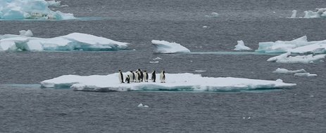
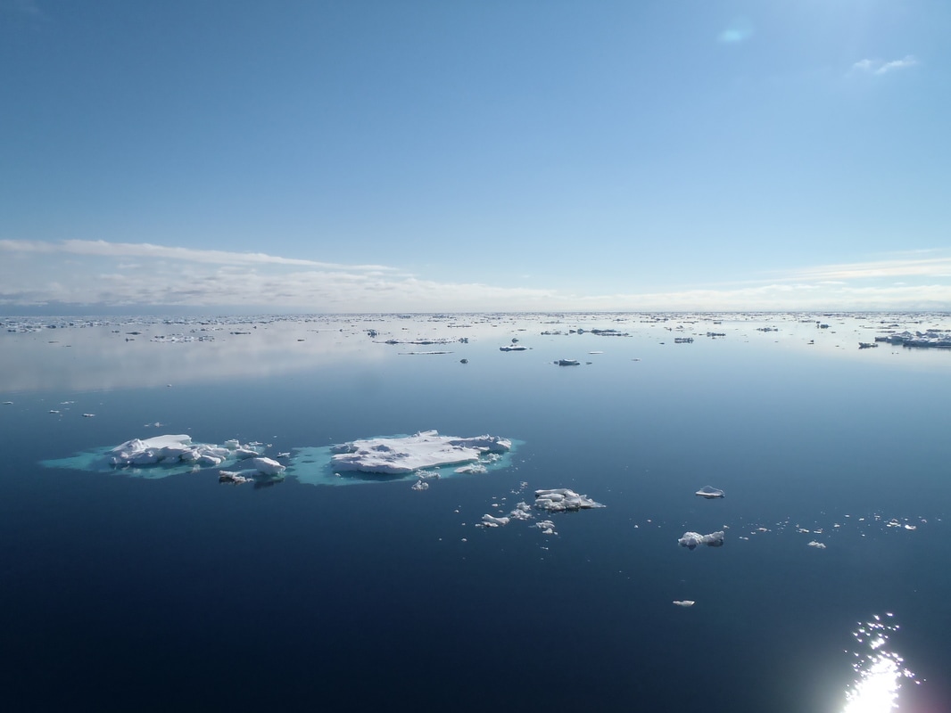
 The JCR in a field of pancake ice. Mmmmm.... pancakes. This post is motivated by a lesson doled out to us by nature over the last few weeks on the dynamic, ever changing nature of sea-ice in Antarctica. To cut a long story short, we stalwart mariners on the good ship James Clarke Ross found ourselves in a little bit of difficulty about 2 weeks ago. Attempting to get into the far south of the Weddell Sea, I awoke one "morning" (really 11:30pm, when my shift working the CTD starts) to find myself not floating on an ocean but instead staring at something that looked like the planet Hoth from The Empire Strikes Back, but with the big-walky-robot-things replaced by a gang of slack-jawed penguins (no big-walky-robot-things? Antarctica can be disappointing sometimes). Essentially, the crack in the ice we had used to get to our current location had closed up behind us, leaving us surrounded on all sides by thick pack ice, with nobody around save a bastard of a crabeater seal who would repeatedly pop his head up from a small hole in the ice near the ship, call us a foul name (which I will not repeat for fear of causing offence) and then disappear. We were, well, just a little bit stuck. Eventually, the we cranked up some AC/DC (hey, I'm Australian, I'm allowed to indulge in some of the best examples of my national culture), put the pedal-to-the-metal and, with the help of two very large engines, a lot of diesel and some choice swear words, managed to bang, ram and smash our way out of the ice and to freedom, FREEDOM I SAY! Finally clear of the heavy ice, safe and sound, we then proceeded to prove that we scientists, as skilled as we are with the manipulation of Greek-symbols, lack just about any common sense. We immediately began negotiations with the ship's captain and officers to try to convince them to turn around and head straight back into the ice field. Yes, the very same ice field that nearly trapped us forever, leaving us at the mercy of the roving bands of man-eating penguins that are known to roam these here parts. Fast forward one week and, with the captain's grudging blessing, we headed back to the southern Weddell Sea and towards our goal of the Flichner Ice Shelf. In doing so, we went straight past the place where we had previously been stuck. The difference in the local environment was, well, striking, as you may be able to tell from the photos below. So from the planet Hoth to that planet from the movie Waterworld (wait a minute.... Himalayan mountains... sunken petrol tankers... that was our planet! You blew it up! You maniacs! Damn you all to hell!) in a week. As a famous philosopher once mused: what gives? In my last post, I gave a bit of an overview of sea ice. Mostly, I blabbered on about where sea-ice exists, why it's important, and how we measure it from ships. Today, as promised, I'll go into a little bit of detail on the physics of sea-ice. Specifically, I'll try to give you an idea of how sea-ice forms. Sea Ice Growth and Formation There is one main ingredient to the formation of sea ice from ocean water: it's got to be cold. However, ocean water is constantly in motion and is full of impurities like salt and dissolved gasses, all of which make the formation of sea ice a far more complicated process than simply putting an ice cube tray in the freezer and leaving it for a few hours before dropping it into a sweet, sweet glass of Bourbon (oh yes, brownest of the brown liquors....). Sea ice, much like a butterfly or the music tastes of an adolescent, has several life stages. Let's take some ocean water and cool it down. We'll cool it down from the top by blowing really cold air over the top, so that the surface layer, that teensy, tiny part of the water that is actually in contact with the air, cools down the fastest. It's here, in the surface layer that tiny ice crystals will form when the water temperature drops below the freezing temperature. These ice crystals will be small, 1mm across or less, and, because as water freezes it expands, will generally float on the ocean surface. What happens next depends a lot on the state of the ocean. In calm conditions, where the ice crystals aren't sloshed around, the crystals will grow outward and join up with their buddies next door, eventually matting together to form a thin sheet of ice on the ocean surface. With nowhere to expand outward, the sheet of ice will begin to grow downwards, thickening up to a layer about 5 to 10cm thick. This ice is called Nilas. It's elastic (that is it bends easily on waves and goes back to its original shape after the wave has passed), crystal clear and breaks when you throw a snow-ball at it (yes, I am a child. Yes, I pretend not to care that you are silently judging me). There's a nifty little series of diagrams I drew below where I try to explain the process. 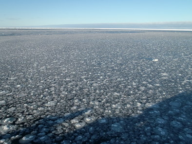 Not just a clever name: a field of Pancake ice in the Southern Weddell Sea. Not just a clever name: a field of Pancake ice in the Southern Weddell Sea. When conditions aren't calm but more sea-sickness inducing, the action of waves and turbulence breaks up the little ice crystals. These broken ice crystals get mashed up together with other broken up ice crystals to form little congregations of ice called frazil. Frazil ice crystals grow up to about 2 or 3 mm, bounce around in the waves and turbulence until enough of them are bound together that they can float to the surface. There, they continue to get sloshed around, colliding with other blobs of ice to form superblobs called pancakes. It might surprise you to know that pancake ice is called pancake ice due to oceanographers, once again, having no sense of creativity in their naming conventions. Here you go, some more nifty diagrams will hopefully make what I've said easier to follow. 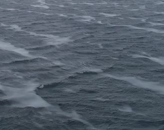 That shiny stuff? That's Frazil ice. That shiny stuff? That's Frazil ice. Most Arctic sea ice gets formed through congelation processes - that is the growth of ice in calm conditions. Winds are generally weaker in the Arctic and, being surrounded by large land barriers like, well, Canada and Russia, there limited ocean swells propagating into the ice from outside. Near the Antarctic however, ice is formed primarily by frazil congregation: being surrounded on all sides by the Southern Ocean, swells and high winds mean that Antarctic waters are rarely very calm. Whether formed in nice sheets of nilas, or big lumpy pancakes, we have now got a thin sheet of ice covering the ocean surface which has direct influence on how the ice continues to grow and evolve. For one, the ice is now insulating the ocean water below it, which slows down dramatically the rate at which the ocean can be cooled by the cold wind above it, and hence, how quickly we can freeze more water and create more ice. Secondly, there is now a surface for ice-crystals to latch onto. Although sheet ice does insulate the ocean below it, ice is not a 100 percent perfect insulator. Ice does conduct heat, so eventually, if you cool the surface of the ice in contact with the atmosphere enough, the bottom of the ice, the bit in contact with the water, will cool down enough to so that the water will freeze and the sheet ice will get bigger, growing from the bottom down. However, as the ice gets thicker, its ability to insulate the water improves, so the rate at which we can freeze water and create more ice drops further still. Basically, the thicker the piece of ice, the slower it will grow. In fact, there's elegant mathematical theories that you're probably not interested in, that show that the growth rate of a piece of sea ice is inversely proportional to its thickness. Once sea ice reaches a thickness of about 10cm, it graduates from the nilas/pancake stage and is upgraded to what we call young ice. This pubescent ice is sufficiently thick that its rate of growth through the freezing of additional sea-water becomes slow enough that it is of secondary importance. Instead, the ice will grow by either accumulating the snow that falls on it, and, much like an adolescent human-being, by smashing into other piece of ice and congregating together. Ice will continue to grow by a combination of these mechanisms until it reaches the equivalent of its 20s: first year ice, that can be anywhere between 30cm and 2 metres thick. This ice has graduated from ice university, yet like a 20-something, still hasn't really found its place in the world. 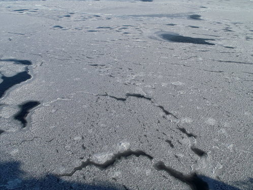 Pancake merging together to form one of the super-big Dutch pancakes that they show on TV when they get large enough to break the Guinness World Record. Or pack ice. One or the other. Ice that's been around the block, accumulated some experience, some battle scars, learned a little, loved, laughed, lost and all those other coming of age metaphors that I promise I'll stop using gets called multiyear ice. This is ice with personality, and by personality I mean it's nasty, hard stuff that is quite happy to smash up an ice-breaker that's bitten more than it can chew.
More than half of the Arctic ice-pack is made up of multiyear ice. However, down south, only a very small fraction of the sea ice has survived a summer, mostly in the western Weddell Sea and parts of the Ross Sea. What this means is that the Antarctic ice pack has a much larger seasonal variation than the Arctic ice: much more of the Antarctic ice melts away during the summer than in the Arctic. There are a few reasons for this, but primarily the cause is that the Antarctic continent gets in the way. While the Arctic ocean spans most of the region from about 70N all the way to the geographic north pole, in Antarctic water, sea ice can only get to about 75 degrees south, before the land gets in the way. So, there you have it. The birth of ice, through its awkward teenage years and into middle age. Now you know. For my next post, I'll talk a little about how sea ice moves around, and why it's movements are so hard to predict.
2 Commentaires
  I'm sorry. I'm afraid that there's no more room. You'll have to find another... I'm sorry. I'm afraid that there's no more room. You'll have to find another... I had originally planned to write another post on oceanographic instrumentation, in particular, Lagrangian drifters. But recently, we aboard the James-Clarke Ross have managed to get into the very far south-eastern part of the Weddell Sea where we've become surrounded by ice. Sea ice in particular. We're not stuck (well not yet), but ice conditions have degraded over the last couple of days, which may hamper our ability to go where we want to go. So, given that I've been staring at the stuff for the last few days, I thought I'd take the opportunity to kick off what will hopefully be a multi-part post on sea ice - what it is, why it's there, and why it's important to know about. It's also a good opportunity to post a bunch of photos. Lagrangian drifters will just have to wait. So, without further ado, here's Chris' super-duper introduction to sea-ice. Hopefully, I'll find the time to go into a bit more detail in a later post. What the hell is sea ice? 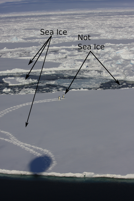 That ought to clear up any confusion. It's probably a good idea to spend 5 seconds defining my terms and say, clearly, what sea ice is an what it 'ain't, as this question seems to trip-up some of the more gullible climate-change skeptics, including politicians and journalists with a far greater readership and influence than myself. Sea ice isn't just "ice in the ocean". Sea ice is ice that forms when ocean water - that is water that is already in the ocean - freezes. When ocean water freezes, the total amount of water in the ocean-ice system stays the same. Thus melting sea-ice cannot contribute to the rise in sea-levels expected to occur (and already being observed) with global warming. Sea-ice is a different kettle-of-fish from land ice, such as the ice in glaciers and ice shelves. Icebergs, for example, are formed by chunks of ice falling of iceshelves or glaciers. Icebergs, although being ice in the sea, are not sea ice. Clear as mud, n'est-ce pas? When ice that was on land either melts and flows into the ocean, or breaks off and falls into the ocean the total amount of water in the ocean increases. In this way, melting glaciers and collapsing ice-shelves can contribute to sea-level rise. That's not to say that melting sea ice is unimportant for the climate system. Au contraire mes ami(e)s, sea-ice has extremely large influence on the climate, which I'll go into in a moment. But those effects don't, directly at least, lead to sea-level rise. Where, and why, does the ocean freeze? 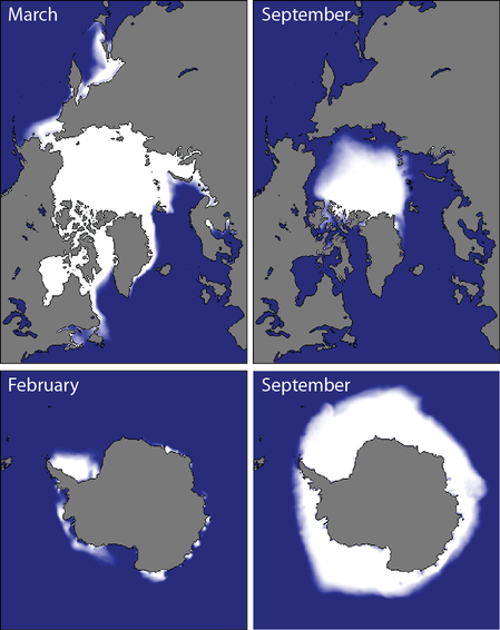 The extent of sea-ice in a "normal" year for the northern (top) and southern (bottom) hemispheres. Taken from the National Snow and Ice Data Centre (http://nsidc.org/cryosphere/sotc/sea_ice.html) The extent of sea-ice in a "normal" year for the northern (top) and southern (bottom) hemispheres. Taken from the National Snow and Ice Data Centre (http://nsidc.org/cryosphere/sotc/sea_ice.html) Since sea ice occurs when the ocean freezes, a better question is probably "why doesn't the ocean freeze more?" After all, much of the ocean is below 0 degrees Celsius, and as someone who has spent the better part of two weeks have this friggin' freezing water poured all over my hands while taking water samples, I can assure you it remains very liquid (it also remains very cold). In fact, sea ice is remarkable because it is rare: only about 10 percent of the ocean surface freezes regularly, and the vast majority of that occurs poleward of about 60 degrees in the Arctic or Antarctic seas. Sea-ice really only becomes bothersome for shipping in northern latitudes and mostly in the winter (there is not much shipping in the regions in the southern hemisphere where sea-ice forms, so the only people who are bothered by it are us scientists and cruise ship patrons who have shelled out exorbitant sums of cash to visit <insert exotic-sounding Antarctic local here> and can't because it's covered by 5 meters of heavy pack-ice). From where I'm sitting at the moment, the water temperature at the surface is -1.4 degrees C. Why isn't the ocean here frozen solid? Well, the short answer is "salinity". The long answer is also "salinity". Essentially, the presence of salt in water lowers its freezing temperature. The freezing temperature of "normal" seawater is about -1.9 degrees. However, the more salt, the lower the freezing temperature. In the Weddell Sea, where I currently find myself, water freezes at about -3 degrees. However, some important shipping areas, such as the Baltic Sea, in between the Scandinavian countries and the rest of Europe, has a much lower salinity and freezes up at a higher water temperature. It should be pretty unsurprising that sea-ice varies with the seasons. It grows in winter and retreats in summer. However, just as one summer may be warmer than another summer, sea-ice shows strong inter-annual variability. That's because sea-ice growth is affected by many external factors: temperature (duh...), but also winds (which not only cool the ocean surface but also blow sea-ice around in complicated ways), waves (which break-up the ice - ice, in turn, kills waves), snow cover which insulates ice and helps prevent it from melting, the amount of sun beating down on the ice surface and a whole bunch of other stuff. The upshot is that a colder year does not necessarily equal a greater ice extent, simply because the wind, for example, may blow the ice back to where it came from. The physics of sea-ice are immensely complicated. Ice is constantly bashing into other ice, breaking, melding together, melting, dissolving and reforming, all of which make it a great challenge to model. Why should you care about sea-ice? Unless you are a Russian freighter captain trying to pilot a cargo of 857,248 beanie-babies (beanie-babies Chris? Beanie-babies? Seriously, what the hell man? Who has given a single solitary thought to beanie-babies in the last 20 years?) through the sea of Okhotsk in winter, sea-ice isn't likely to affect your day-to-day activities. But we oceanographers and climatologists are interested in sea-ice as it has extremely important effects on the climate system. This is a subject in and of itself, and impossible to encapsulate in a single blog post. As I keep mentioning, I'll try to fill in the gaps in a dedicated post. Probably the most well known of these effects is the "ice albedo" effect. Simply put, ocean water, absorbs most of the sunlight that falls on it, whereas ice, and particularly snow covered ice, reflects pretty much all of it. As such, sea ice acts as kind of inbuilt cooling mechanism for the planet. However, sea-ice has a multitude of other effects on the climate, both in the local region where it is formed, and for the global climate. One that does not get a lot of press, even in scientific circles, is that sea-ice puts a cap over the ocean where it forms, which means that the ocean is now cut-off from the atmosphere. Under normal (that is, open ocean) conditions, the atmosphere and the ocean exchange heat, mass and momentum. Winds, blowing over the ocean's surface exert a stress which is basically a transfer of momentum from the atmosphere to the ocean. Similarly, warm or cold air blowing over the ocean surface can either heat-up or cool down the ocean water. Both of these phenomena are essentially what drive the major ocean current systems. When sea-ice is present, however, winds blow not directly on the water but on the ice itself. Now the atmosphere must talk to the ocean via an intermediary, the ice. Wind blows on the ice, the ice moves, and the moving ice pushing on the water causes the water to move, and so-on.The ice also insulates the ocean, like a lid, and stops it from losing heat to the atmosphere. Somewhat counter-intuitively, sea-ice helps keep the ocean warm (if you can call -1.5 degrees warm). 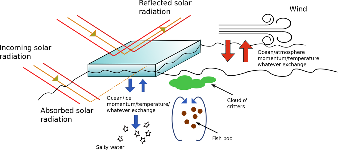 Schematic showing a few of the multitude of different ways sea-ice affects the ocean/climate system. I made this diagram myself, so you're not allowed to make fun of it. Sea ice has some other important effects as well. One of the most well studied is the phenomena of "brine rejection". Sea ice, despite being made-up of ocean water, is very fresh: there is almost no salt in sea ice. When the ice crystals form, they kick out the dissolved salt. That salt has to go somewhere, so it generally goes directly into the ocean below, making it more salty and, therefore, denser. The formation of sea-ice is very important for the formation of the very dense Antarctic Bottom Water, that fills much of the ocean from the bottom-up (I've written a little about AABW before). If there were no sea-ice, the interior of the oceans would look very, very different. Finally, the area near the edge of the sea ice, the so-called "Marginal Ice Zone" is incredibly productive biologically. In these regions, a complex interaction between ocean, wind and the ice, cause nutrients (read: fish poo. Lots and lots of fish poo) to be brought to the surface from below, where it is used by microscopic water-born plants (pytoplankton) who get eaten by tiny animals (zooplankton), who get eaten by bigger critters, and so on up the food chain. Primary productivity, a measure of the intensity of the base of the food chain, is off the charts in these regions, which has all sorts of flow on effects, from sucking of CO2 out of the atmosphere (pytoplankton, being plants, consume CO2 during photosynthesis) to the colour of the ocean. The list of ways that sea-ice influences the global climate doesn't end here, although my condensed version does. A more detailed post is in the making. Measuring sea-iceWhen we talk about measuring sea-ice, we're generally interested in four things, which are, in order of importance:
Let me illustrate my point with an example. Take a look at this photo: 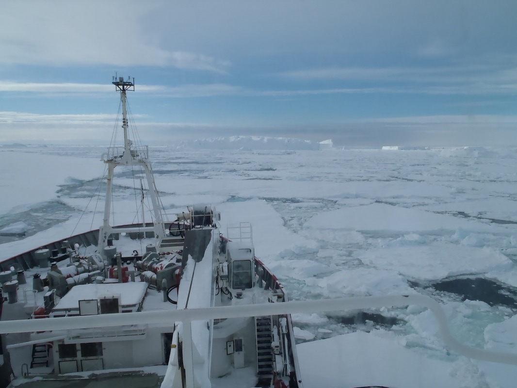 Ice in the south-eastern Weddell Sea. This blog isn't just an excuse to post photos, I swear. 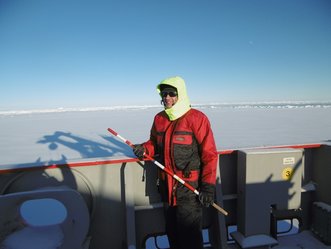 To explain the bright yellow hood, I'll simply state that it was -21 degrees when this photo was taken. To explain the bright yellow hood, I'll simply state that it was -21 degrees when this photo was taken. Now, tell me what the concentration of the ice is, and how thick it is. The photo shows a bit of a mess. Ice bergs (which, I'll remind you, are not sea-ice) mixed in with snow (also not sea ice) mixed with cracks in the ice, mixed with man-eating penguins, mixed with who knows what else. It takes a skilled observer and a large amount of experience to make useful observations of ice concentrations and types from ships. Measuring thickness is even more difficult. Much like the stereotypical iceberg, where the majority of a chunk of sea ice lies below the surface of the water (fun fact: the part above the surface is called the 'freeboard', the part below, the 'draft'. You are now primed to crush your next local pub quizz-night). Thickness is vitally important for shipping. The James Clarke Ross can break ice that's one meter thick with no problems. Ice that's 5 meters thick can break the James Clarke Ross with no problems. So to measure ice-thickness, we use a sophisticated instrument called a Statistical Transmorphic Ice Calibration Kit (STICK). Here's your humble author brandishing this piece of cutting edge technology. Now, here is a photo of STICK in action. 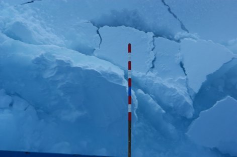 No, I can't think of a more exciting picture to post than a picture of a stick. Blame Andrea, who sent me the photo. 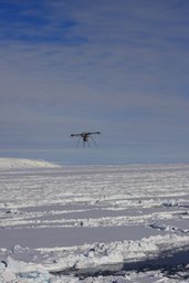 Flying a quad-copter over Antarctica. Sometimes, I think my job is pretty cool. Flying a quad-copter over Antarctica. Sometimes, I think my job is pretty cool. Yes, that's right. We use a broom handle, divided up into 10cm sections, to measure the thickness of ice turned over by the ship as it passes through an ice field. Sophisticate, eh? Sometimes, I've waited 15-20 minutes for a nice block of ice to turn over. Which, in Antarctic temperatures (it's been consistently below minus 15 degrees C), starts to wear at ones patience. We've also recently been experimenting with using a drone to estimate the sea-ice concentrations, types and floe sizes, although to-date, we haven't had much luck as our opto-electrical (visible) camera failed. But in the future drone technology will allow us to combined ship based estimates with quick-n-easy aerial surveys, something I'm really looking forward to working with more in the future, and not just because, like any self-respecting nerd, I like playing with shiny new toys. I'm going to finish up this post here, as it's already gotten longer than I had initially planned. Suffice to say sea ice is both super important, and super interesting. Hopefully, I've given you a taste of that. A note on attribution Many of these photos weren't taken by me. In fact, I've been stealing photos left, right and centre, trying to get the best ones, for your viewing pleasure.
Many in this post were take by Helen, the ship's doctor. She blogs on our adventures at Baby it's Cold Down Here and has some amazing photos. So go show her some love. Many other photos come from my friends and colleagues, Yves and Sara, our resident biologists who do ice observations while I sleep. They have their own blog (en francais, bien sur. On bosse en France normalement!) over at Immersion sous la Banquise en Antarctique (Immersion under the Antarctic Sea Ice). More fantastic photos await. 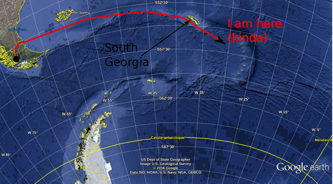 We're a long way from Kansas, Toto. Not sure why that's important, since neither of us are from Kansas, but it's true nevertheless. In my last post, I explained a little about why we oceanographers are interested in the temperature (T) and salinity (S) of the oceans. Today, I'll show you how we do it from ocean going research ships, illustrating with a couple of photos from the first couple of measurements we made south of the island of South Georgia (one of the many places that Ernest Shackleton didn't die). How it's done. This is a CTD. 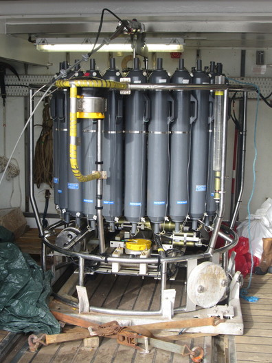 CTD is a complicated way of saying bottle rack. CTD stands for Conductivity, Temperature, Depth. It's not just a clever name: this device really does measure the conductivity, the temperature and the depth. Oceanographers are known for their creative naming conventions. Conductivity is a measure of how electrically conductive a substance is (if you've ever done electronics, you'll know conductivity as the inverse resistance). Water that is more saline is more electrically conductive. With careful calibration of the instrument - a job in an of itself - if we know the conductivity of a water sample, we know its salinity. From afar, the CTD might look like a rack of bottles. That's because a CTD is, primarily, a rack of bottles. Ours has 24 bottles that can hold 12 litres of water. These bottles are attached by latex wires to a magnetically operated trigger. By lowering the CTD into the ocean on a winch, we can take water samples at any depth that interests us. An operator, usually a skilled and experienced oceanographer, but in some cases, me, "fires" a bottle, which causes it to snap closed at a depth that interests us. We've got 24 bottles, which means we could, if we wanted to, sample water from 24 different depths. However, for a lot of chemistry and biology work (measuring, for example, the amount of CO2 or oxygen dissolved in the water, or the amount of plankton or whatever), you need a lot of water, so we'll often "fire" two bottles at the same depth to give our colleagues more material to work with. Here's a CTD on wire being winched over the side of the ship. 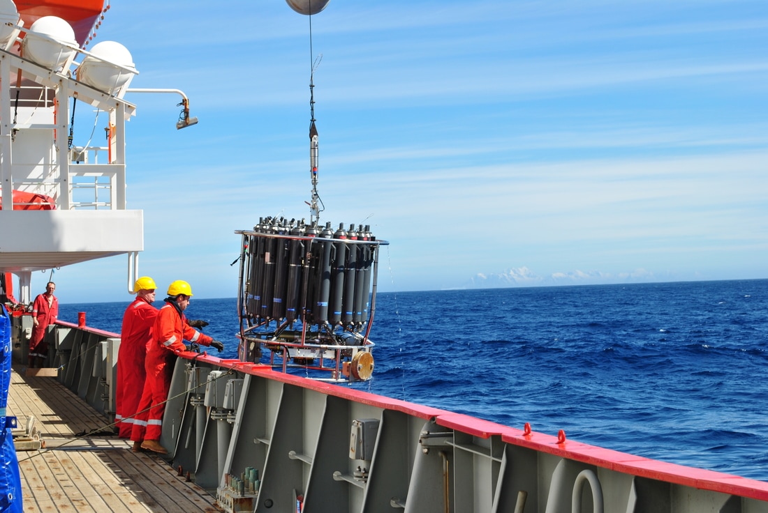 This guy has a date with the bottom of the ocean! (you can just make out the mountains of South Georgia in the background) 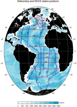 WOCE sections in the Atlantic (from the WOCE Atlas woceatlas.ucsd.edu/) WOCE sections in the Atlantic (from the WOCE Atlas woceatlas.ucsd.edu/) We lower the CTD down to about 10 meters above the ocean floor (getting the CTD stuck on the bottom of the ocean is generally considered to be a dick move). We then winch it up to the surface, taking water samples as we go. When we get it back on the ship, the water samples are divided up among the assembled waiting chemists, who then proceed to science the crap out of them. Some of the water samples are scienced in labs on board the ship. Others are packed up and sent back home at the end of the campaign for further sciencing on land. Some lab equipment, such as electron microscopes, and... I dunno... an elephant or something (I'm not a chemist) you just can't take on a boat. These days, CTDs also have electronic temperature and conductivity (salinity) probes which measure, in real time, the T and S of the ocean, as well as some other interesting quantities such as "florescence" (how much ocean water glows when you shine a light on it... an indirect measure of the amount of phytoplankton in the water) or dissolved oxygen. The information is the sent back up to the ship via a cable and we can monitor how the T & S change with depth as the CTD is lowered and raised. This real time information helps us decided at exactly which depth we want to sample water at. Most plankton activity, for example, happens relatively close to the surface in an area called the "mixed layer" whose depth depends on the strength of the wind, waves, location, time of year, etc... The mixed layer gives itself away by being ... well... mixed - that is, its temperature and salinity are relatively constant throughout its depth. The bottom of the mixed layer is marked by a very strong temperature gradient. For our friends the biologists, we want to be very sure to sample this region, so we keep a close eye on the temperature as the CTD goes down (and comes up again) to give us an idea about where in the water column to sample. The electronic temperature and conductivity probes are good enough these days that we use their data pretty much as we would bottle samples. However, we do check the temperature and salinity collected via the bottle samples against the electronic equipment to make such that both are working well, and that the calibrations haven't "drifted" too much. Where do we do it? The oceans are big. Boats are small. Even with 10,000 boats piloted by crack team of super intelligent talking mice, covering the world's oceans would be a futile task. That's why, back in the late 80's, a scheme was launched, called the World Ocean Circulation Experiment (WOCE) to divide the ocean's up into "sections" or "transects". These sections were carefully chosen because the people in charge of WOCE wanted to measure certain interesting ocean phenomena. For example, the section SR1, which runs between the tip of South America and the Antarctic Peninsula was designed to measure the strength of the Antarctic Circumpolar Current as it passes through Drake Passage (the passage between, err... the tip of South America and the Antarctic Peninsula). Each section is divided into a number of "stations": points along the line where we deploy our CTD (and other instruments if you've got 'em). The ship comes to a stop at each of the stations, and we role out the ol' CTD and take a profile at that location. Ocean going field campaigns should, subject to weather conditions, timing, cruise objectives, etc... take their measurements along one of these "sections" at its appropriate stations. By repeatedly sampling the same parts of the ocean, we can build up a good body of knowledge about the ocean in particular areas, as well as see how things change in that area with time. Systematic sampling is usually (although not always) better than sampling au hazard. It enables easy comparison with what's gone on before and allows (kinda) continuous monitoring of certain interesting phenomena. Before we get to the Weddell Sea, we on the WAPITI cruise will be "occupying" (that is, re-sampling) the southern part of the A23 line - between the bottom of South Georgia island and the Antarctic continent. A23 is a bit of a "forgotten" transect, having only been occupied a few times previously. As it's on the way to our principle destination, we (and by "we" I mean my boss and the head-honchos at the British Antarctic Survey) thought that it would be a good idea to take some samples along this transect during the voyage.  We're doing this bit (also from the WOCE Atlas: woceatlas.ucsd.edu) So that's the basics of how we measure T & S (and some other stuff) during a research cruise. I should mention that this isn't the only way to measure T & S. We can also measure both quantities by satellites (but only at the surface, of course) by moored instruments stuck to the ocean floor (but on in one place, of course) or by drifting robots called Argo floats (but then you don't know where exactly you'll measure).
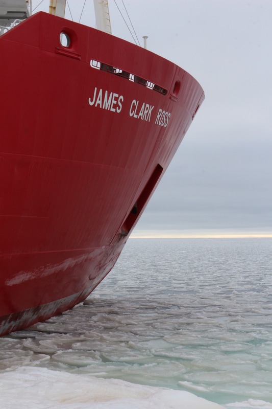
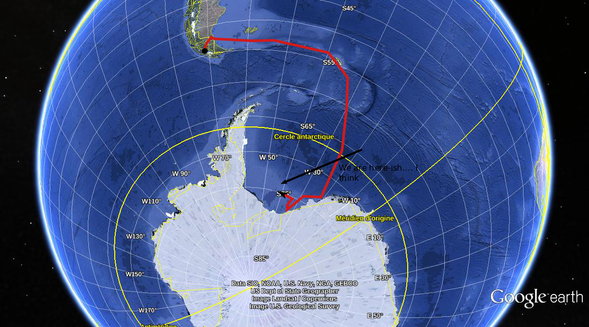
In my next post I'll describe the hows and whys of measuring the speed of ocean currents and why that's an important thing to do.  The most accurate chart in the world! 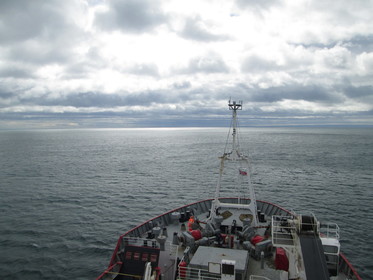 The James Clark Ross leaves Punta Arenas - heading for parts unknown.... to those who have never heard of Antarctica. The James Clark Ross leaves Punta Arenas - heading for parts unknown.... to those who have never heard of Antarctica. I'm aboard the RSS James Clark Ross, having left Punta Arenas in the far south of Chile. We're "steaming", to use the nautical term, for Bird Island in the South Georgia island chain. We will be dropping off some lucky scientists who will be spending some time there taking lake sediment samples, before making a turn to the south. It's after this turn where my work really begins. I'm charged with measuring the temperature and salinity "profiles" (that is, measuring the temperature and salinity as they change with depth) along a "transect" (A23 to be precise - I'll explain what that means in my next post). Why do oceanographers bother measuring T & S? And how, in a deep, constantly moving ocean, do we do it? Today, I'll briefly explain the former question. A little later, I'll describe the later. Why are T & S important? Well, for a start, animals that live in the ocean are generally adapted to certain temperatures and salinities. Coral is a great example, and one that gets a lot of press. Tropical corals can only survive in a narrow temperature range: when the waters get too warm (as is already occurring in some parts of the world as global warming starts to leave its mark on the planet), the corals get stressed and, eventually, die. Almost every animal in the ocean exploits some ecological niche, and both T & S play a key role in defining them. However, for a physical oceanographer such as myself, temperature and salinity are so much more than just two ingredients essential for marine life on Earth. They are also primary drivers of the ocean circulation - a fundamental component of the climate system. Both temperature and salinity influence ocean circulation through their influence on the density (that is the mass of the water in a particular volume, say one liter - sometimes called the buoyancy) of ocean water. Warmer water, all things being equal, is less dense (we could also say "lighter" or "more buoyant") while colder water is more dense ("heavier" or "less buoyant"). Salt has a similar effect: after all, if you 10g/oz/whatever quantity to a bottle of water, it will weigh 10g/oz/whatever more than before and hence be more dense (as the volume of liquid hasn't really changed). If you drop denser water in lighter water, it will sink (yes, yes, you the oceanographer in the crowd, I know it will entrain fluid and mix as it does. Shut up for a second and let me go on) until it reaches a level where its density is the same as the density of the surrounding fluid. This effect is why the densest ocean waters - the coldest and the saltiest - are the deepest: they've had time to sink the bottom and "fill" the ocean from the bottom up. The change in the density of seawater with its depth is what oceanographers call "stratification" and it's a fundamental property of the ocean that affects all sorts of things, such as ocean turbulence and how similar the currents at the surface are to the currents at depth. 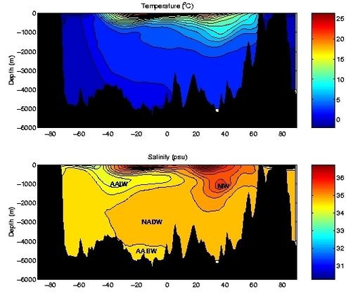 A slice of temperature (top) and salinity (bottom) through the Atlantic Ocean. Some of the water masses are labelled in the salinity image. Image from: http://www.soes.soton.ac.uk/teaching/courses/oa631/hydro.html 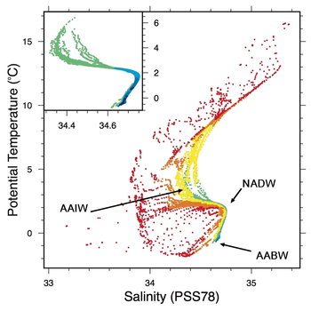 It should be obvious to the most dimwitted individual where to find the AABW! From colleagues at the Muséum National d'Histoire Naturelle, Paris: http://edu.mnhn.fr/mod/book/view.php?id=5405&chapterid=96&lang=en It should be obvious to the most dimwitted individual where to find the AABW! From colleagues at the Muséum National d'Histoire Naturelle, Paris: http://edu.mnhn.fr/mod/book/view.php?id=5405&chapterid=96&lang=en The temperature and salinity of the oceans change depending on where you are, and in what season. Obviously, water is colder - hence denser - at the poles than in the tropics, simply because the tropic get more and stronger sun than the Arctic or Antarctic. However, some regions of the tropics get a lot of rain, which dilutes the salt in the water, while some sub-tropical regions have very little cloud cover, so the sun beams in a bakes the ocean surface. In these "horse latitudes" the salinity is very high as much of the surface water evaporates, leaving more concentrated salt. Hence water in the sub-tropics can often be quite dense, even though the water can be quite warm.
By collecting thousands upon thousands (upon thousands) of water samples we can start to see patterns between the temperature and salinity of the water, and where it has come from. For example, as I was describing before, warm, salty water was probably formed in the sub-tropical regions, while warm, yet non-salty water (so called "fresh water", even though it still may have plenty of salt in it) might have come from the wet-tropics. We call these unique(ish) combinations of temperature and salinity "water masses", and any attendee of an oceanographic conference will hear a barrage of odd names and acronyms - NADW, AAIW, Mode Water, etc... that are the names for different water masses. Each water mass comes with baggage: a story about how it managed to find itself with the T & S it possesses. And finding a particular water mass a long way from home can help give us an idea of the pathway that it took to get from its point of formation to wherever it has ended up, which can in turn help us understand how the ocean currents move. On the WAPITI cruise we'll be chasing so-called "Antarctic Bottom Water" (abbreviated AABW). This water mass is the densest you can find: it's cold because it comes from the coasts of Antarctica, one of the coldest regions on the planet. It's salty, because near Antarctica lots of sea-ice is formed. The water that makes up sea-ice is quite fresh - sea-ice rejects salt from the water as it forms - and this salt ends up in the water below the sea-ice. Thus, AABW has a pretty clear signature: colder than -0.2 degrees C (it won't freeze because it's both too salty and under pressure) and saltier than about 34.6 psu (that's Practical Salinity Units for those not up on their oceanographic metrology). AABW is so dense that it sinks pretty-much straight to the bottom upon being formed. But it doesn't just lay around on the ocean floor like Brad Pitt in the underrated Tarantino film True Romance (you have no idea what I'm talking about, do you?). We find AABW all through the Atlantic Ocean, indicating that it has spread to the north after being formed. What's more, AABW is rich in dissolved CO2 that it has absorbed from the atmosphere. Since AABW stays on the ocean floor for centuries or even millennia, its CO2 stays there with it, where it can't contribute to global warming. But wait, there's more! Through the magic of a simplified description of ocean currents, called the geostrophic balance approximation (which says that the Corriolis force and the pressure gradient force are the dominant forces in the ocean, and that the two act to balance each other), we can directly relate the ocean's density structure to the ocean currents themselves. So if we know the ocean's density structure (that is, how the density changes in latitude, longitude and depth) we get an approximation of the ocean current speed for free (although we miss a very, very important constant factor called the "barotropic current" that can be thought of as the average of the current speed in the water column). On the WAPITI cruise, we'll use our "transects" or "sections" of T & S to estimate the geostrophic current speeds in the Weddell Sea, which can give us an idea about how rapidly the AABW is moved from its formation regions to the open ocean. This (longish) post explains a little about why T & S are important to measure. It's a simplified picture, and I've skipped a bunch of details like the effect of mixing, internal waves and the importance and difficulty of estimating the barotropic current. But it should give you the gist. In my next post, I'll show you how we measure temperature and salinity from ships, with some real world examples from our first CTD casts. 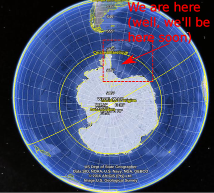 I'm just about ready to leave for a 6 weeks a sea, confirming my transition from a mathematician to a "real" oceanographer as part of the Water-mass transformation and Pathways In The Weddell Sea (WAPITI) project, an EU funded project run by my boss, oceanographer and noted acronym creater Jean-Baptiste Sallée. WAPITI will head to the Weddell sea, of the coast of west Antarctica, aboard the RSS James Clark Ross and I'll be attempting to keep this blog updated as we intrepid explorers brave the cold, the waves and man-eating penguins of the far south in the name of science. What is WAPITI and why, in this day and age of satellites, supercomputers and cheap postdocs would we get on a boat and bob around in the ocean for a few months? Firstly, why the Weddell? The Weddell Sea is the ocean that lies between the Antarctic Peninsula and the Antarctic Continent. The circulation in the region is a gyre, a circular flow that intensifies along the western coastline. 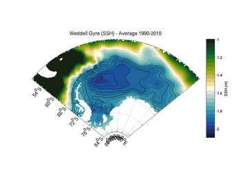 The sea-surface height in the Weddell Sea, as determined by the FESOM ocean model. Flow follows the contours in a clock-wise direction. The sea-surface height in the Weddell Sea, as determined by the FESOM ocean model. Flow follows the contours in a clock-wise direction. Gyres are generally thought to be driven by wind blowing over their surface. In fact, gyre flow is one of the most celebrated results in oceanography. But the Weddell is covered by sea-ice, that extends further north in winter and retreats in summer. Sea-ice modifies how the wind "talks" to the ocean in subtle ways that could impact the Weddell Sea gyre. 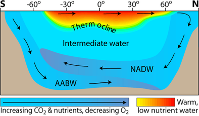 From: http://www.seos-project.eu From: http://www.seos-project.eu Oceanographers can also be a bit obsessed with the Weddell as it is one of the few regions on Earth where Antarctic Bottom Water (AABW). AABW is the densest (it's cold and salty), and hence the deepest, water found in the oceans: it fills the ocean from the bottom-up. AABW is formed near the ocean surface in a complicated process involving both freezing water to form ice and cooling from winds blowing over the ocean. Then, as it is so dense, it sinks. Because AABW is formed at the surface, when it sinks it takes with it dissolved oxygen and CO2. Once the CO2 is in the deep ocean, it stays there for hundreds, perhaps thousands of years. The diagram below gives you an idea of what's going on. That's all well and good. But AABW is notoriously difficult to monitor. Once it's formed, it plunges straight to the bottom of the ocean, deeper than most of our instruments are able to measure. We also can't see it from satellites. Even in the regions where the AABW is at the surface, the ocean is generally covered by ice, which make satellite observation impossible. 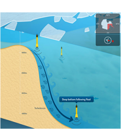 From the WAPITI website. Design by http://cyriljagot.com/ From the WAPITI website. Design by http://cyriljagot.com/ Additionally, no one really knows what's going on under that ice? How does sea ice affect the ocean circulation? We have some ideas, but they're mostly from the Arctic, where the ocean dynamics are quite different? We can, of course, blast this problem with a big ocean model run on a supercomputer, but models have struggled to get the flow right in the Weddell sea, and we really don't have enough data to validate a model anyway. So, we're going to get on a big boat, head south and measure the hell out of the region. What will we be doing? For one, we're going to deploy some special robotic floats. These floats drift (called RAFOS) with the current and measure the current speed as they go. Our floats are special as they are designed to follow the AABW as it flows through the Weddell Sea. These floats are even acoustically tracked, so they don't need to surface like Argo floats to talk to satellites, which means that sea-ice at the surface is no impediment! We're also going to be measuring the strength of the Weddell gyre, using current measurements from moorings and ship based instruments called an Acoustic Current Doppler Profiler (ADCP), as well as a battery of other oceanographic instruments. 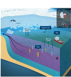 From the WAPITI website. Design by http://cyriljagot.com/ From the WAPITI website. Design by http://cyriljagot.com/ What we hope to achieve is to observe the formation of the AABW, how it gets mixed up by turbulence along the Antarctic coast, and how the Weddell gyre acts to move this water from its formation zones to the open ocean. Over the next few weeks I'll fill in the gaps in this overview, explain what we do on this cruise, and why we do it. I'll also try to put things in context: what does the Weddell Sea mean for the rest of the climate system, and how does our mission help to fill the gaps in our knowledge.
There will also be lots and lots of photos of pieces of ice and charismatic megafuna. So stay tuned. |
Chris Chapman
I'm a physical oceanographer at LOCEAN Paris. My research concentrates on the Southern Ocean and its role in the climate system. ArchivesCategories |

 Flux RSS